Planning a multi-day cycling route from Amsterdam out into the Dutch countryside and worried about losing navigation on rural bike paths? This article will help you to understand connectivity along popular Dutch cycling routes, what terrain and weather to expect, and how to plan a multi-day itinerary without losing signal. After developing a complete understanding, you can make a better decision on your data setup before you start pedaling.
The country’s flat terrain and dedicated cycling infrastructure, including thousands of kilometers of signed bike paths, make it one of Europe’s most approachable regions for a multi-day self-guided ride, whether you are following the coast, the river routes, or a loop through traditional windmill villages.
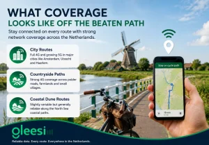
The Netherlands has one of Europe’s densest network infrastructures, so even rural polder roads and dyke paths typically retain solid 4G, unlike mountainous regions elsewhere in Europe where terrain blocks signal.
Coverage density: the number of network towers per square kilometer in a given region, directly affecting how consistent mobile data feels in rural versus urban areas, and a key reason the Netherlands performs so well compared to more mountainous countries.
Spring and early autumn offer the most comfortable cycling conditions, avoiding both winter winds off the North Sea and the busiest summer crowds around Amsterdam’s most popular routes. Wind, more than rain, tends to be the bigger factor for cyclists here given the flat, exposed terrain.
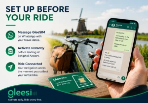
Message GleeSim on WhatsApp with your travel dates and activate before landing at Schiphol. Your navigation app works from the moment you collect your rental bike, letting you head straight out of the city without stopping to sort out connectivity first.
| Route Type | Coverage | Notes |
| City cycling paths | Strong | Full navigation reliability |
| Rural polder and farmland | Strong | Dense infrastructure, flat terrain |
| Coastal dune paths | Moderate to strong | Generally reliable |
| Windmill village loops | Strong | Well covered given tourist traffic |
Is data fast enough for turn-by-turn cycling navigation? Yes, Dutch network speeds comfortably handle live navigation apps even at a steady cycling pace.
Can I top up if my trip runs longer than planned? Yes, message the same WhatsApp thread anytime during your trip for an instant top-up.
Is the whole country flat enough that coverage never dips? Coverage is unusually consistent nationwide, though very rural stretches can occasionally see brief dips, similar to any country’s quietest back roads.
Do I need special gear for a multi-day self-guided ride? Beyond a reliable bike and basic repair kit, a working data connection for navigation and accommodation bookings is one of the more overlooked essentials.
Is Amsterdam itself bike-friendly for a first day before heading into the countryside? Yes, the city’s dedicated cycling infrastructure makes it a comfortable starting point before a longer countryside route.
Plan your route with the Netherlands destination page or buy your bundle at offers.gleesim.com.